What Do We Find When We Track Sailfish Continuously?
Using pop-up satellite tags, scientists can get a much better understanding of billfish movement and migration.
Research Need
Typically, researchers measure the movement of large, offshore pelagic fish using traditional streamer tags, but to get information, the fish must be caught again. This method only provides information on the tagging and recapture locations, but no information about what the fish did in between, including movements up and down the water column.
Ideally, to get the best understanding of how, where, and why a species interacts with its environment — and ultimately where to fish for it — a 3D map would incorporate depth with high-resolution horizontal movement.
What did we study?
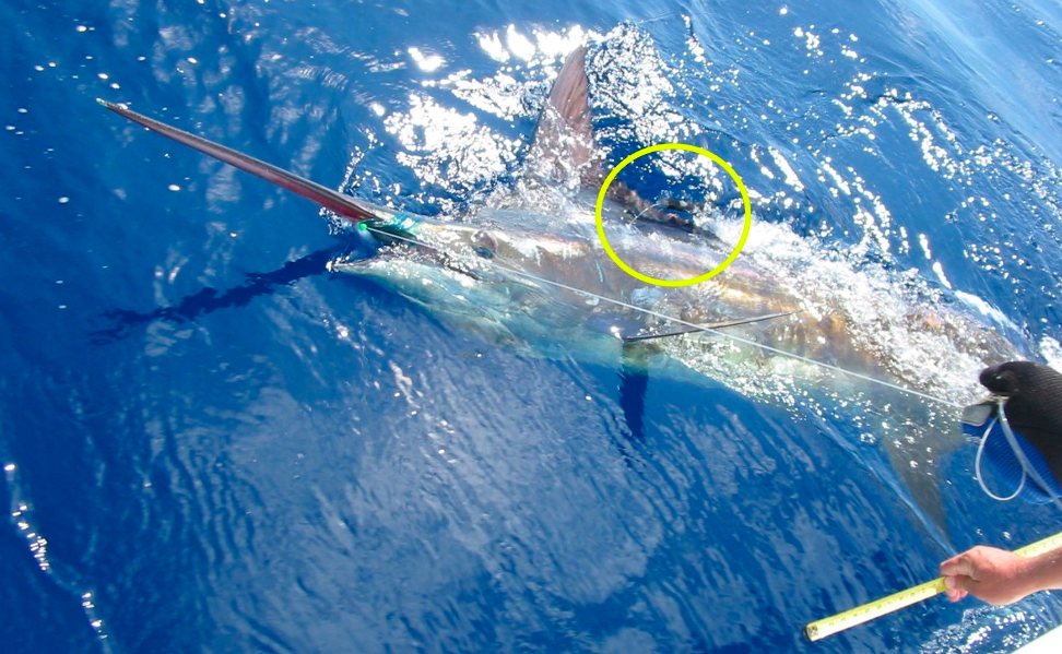
We used pop-up satellite tags to track the movement of billfish caught in South Carolina Governor’s Cup tournaments. These tags capture the 3D location while attached, using sunlight and pressure sensors. The tags pop off at pre-programmed times and, once at the surface, transmit information to satellites and ultimately to the researcher.
We then used this information to provide a 3D model of movement.
What did we find?
One species of billfish (sailfish) off the coast of South Carolina moves seasonally and tends to stay closer to shore. But sailfish will venture offshore, too, including as far north as New Jersey and as far south as the northern coast of South America.
The depths through which fish travel change throughout the day and potentially during different types of movements, such as whether the fish are migrating or staying in an area to feed.
Overall, by tracking depth, we can capture a more complete picture of what these fish are doing and how they interact with their environment and with other species, which we might miss otherwise.
Anything else?
The advantage of satellite tags over streamer tags was apparent in one sailfish especially. This fish traveled to Turks and Caicos before returning to within 150 miles of where it originally was tagged, before its tag finally surfaced.
If this study had used a typical streamer tag on this fish, the only information we would have gathered is that this fish covered the same amount of area that a garden snail could cover over the same time period. Obviously, we would have assumed that likely something more happened with our fish, but without data to know what. Using the satellite tag, however, revealed the fish was much more active.
So what?
Depth plays an important role in limiting competition for food between sailfish and other species. Knowing these differences is especially important in some commercial fisheries, which can be a major source of mortality.
Understanding sailfish and other billfish movement patterns can allow for management and fishing practices that target only the species of interest, while minimizing interactions with billfish species, in turn making them more available to recreational fishermen.
Reading
Walter J. Bubley, Benjamin Galuardi, Amy W. Dukes, and Wallace E. Jenkins’s “Incorporating depth into habitat use descriptions for sailfish Istiophorus platypterus and habitat overlap with other billfishes in the western North Atlantic,” in Marine Ecology Progress Series, Vol. 638: 137–148 2020, https://doi.org/10.3354/meps13239.
Summary compiled by Walter Bubley
Lead photo by SCDNR
NOAA Fisheries, the Guy Harvey Ocean Foundation, and the SC Governor’s Cup Billfishing Series provided support for this research.
The text from Hook, Line & Science is available to reprint and republish, but only in its entirety and with this attribution: Hook, Line & Science, courtesy of Scott Baker and Sara Mirabilio, North Carolina Sea Grant. HookLineScience.com
Sign up for the Hook, Line & Science newsletter here.
- Categories: